daisetsuzan
Tokachi-dake & Biei-dake
The hike
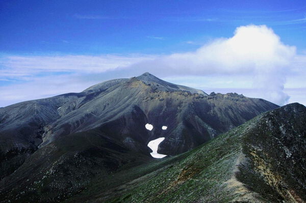
The Tokachi Mountains (十勝山地) are a solid ridge of volcanoes connected to the southern part of the Daisetsuzan National Park (大雪山国立公園). The tallest of these, its billowing smoke and characteristic peak distinctly visible from the Furano Basin, is Tokachi-dake (十勝岳).
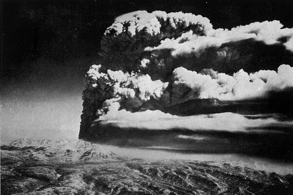
An eruption in 1926 caused a landslide that all but destroyed the town of Kamifurano (上富良野町) and resulted in 144 people missing or dead. You can still see the results of this eruption on the face of the long ridge of mountains coming down from the main bulk of the Daisetsuzan: surrounded by the densely-forested Biei-dake (美瑛岳) and Furano-dake, Tokachi is mostly bare and rocky, the result of the 1926 eruption's ensuing landslide.
Tokachi-dake's name almost certainly comes from the Ainu word tokapchi, which could mean 'dried up' or 'parched,' in reference to either the river flowing from the mountain's eastern flanks, or to the people who lived on the Tokachi Plain, the river's watershed. Biei-dake, on the other hand, sits to the northeast of Tokachi-dake and is the headwaters of the great Biei River (美瑛川), which gives the mountain its name. 'Biei' come from the Ainu pie, meaning 'oily,' and almost certainly refers to the sulfur that leaches into the water.
In this guide we'll make Bogakudai (望岳台) our starting point. Bogakudai sits 4 km from Shirogane Onsen (白金温泉), at the foot of an old ski field. Though the ski field closed in 1999, you can still see some remnants of the old lifts if you look for them.
Due to the Great Taisho eruption in 1926 (and ensuing eruptions in 1962 and throughout the 1980s), the views are just about unmatched here. Walking along the broad trail on a clear day, you should be able to see the little wooden shelter (避難小屋) halfway up the mountain. Along here as well, you will encounter the trail coming from Fukiage Onsen Hakugin-sou (吹上温泉白銀荘), from off on the right.
(It's a bit of a walk, but starting the hike from Fukiage Onsen is a great option. It's got a huge parking lot, a generous campsite, and in my opinion, one of the best onsen in Hokkaido.)
At Kumo-no-daira Junction (雲ノ平分岐), you'll hit the trail coming down from Biei-dake, and shortly afterwards, arrive at the emergency hut. This small hut isn't staffed but it is open year- round. There's no available water outside of what you can collect from snowmelt (which disappears quite early in the season, due to the exposure). Past the emergency hut you'll head up a ridge of scree. The terrain is tough but you'll start gaining some serious elevation here. If you look to the south, you can spot Mae-Tokachi-dake (前十勝岳), where the volcanic smoke roils thickly and from which you might get a sense of the mountain's power.
The grade levels off temporarily as the ridgeline flattens out north of the summit. Around here there are a number of side-trails, so when visibility isn't great it's easy to get lost. These trails are leftover from climbers in the springtime, who make their way up the snowy valley south of the main trail.
From the 1821-meter plateau up to the shoulder of Tokachi-dake, another steep slope begins. The trail gets crumbly and quite sandy so it ends up being a doubly tiring climb. East of here too it's likely that a little snow will remain. As you make your way up onto the shoulder, you'll mount the ridgeline coming around from Mae-Tokachi-dake and keep climbing that ridge up to the summit.
From the summit of Tokachi-dake you'll have a 360-degree view over the Tokachi as well as the Omote-Daisetsu Mountains, as well as towards Ashibetsu-dake (芦別岳) over the Furano Basin. The view from the top of Tokachi-dake is actually one of the best glimpses of what Hokkaido looks like on the whole, geographically.
Heading towards Biei-dake, the ridgeline gets quite windswept, so it's easy to lose your way -- especially around Hira-ga-take (平ヶ岳). If the weather is bad it might be a good idea to head back down the trail you came up and take refuge at Bogakudai. Shortly after you leave the Tokachi-dake summit you'll encounter the trail coming up from Shintoku Town (新得町). Once you pass the broad Hira-ga-take, the ridgeline will sharpen out again near Nokogiri-dake (鋸岳). The ridge of Nokogiri- dake curves around to the northwest, but the hiking trail drops off the eastern slope to traverse a ridge in the northwest. After a short trip down this slope, you'll hit the col and start the long climb up to Biei-dake.
South of the peak of Biei-dake is a steep drop-off, so track east along the ridge and keep an eye out for landslides. Past the Biei-fuji Trail Junction the ridge gets quite narrow, but you'll shortly arrive at the summit of Biei-dake. From here you'll be able to see over the steep valley headwaters of the Ponpi-sawa (ポンピ沢) the full mass of Tokachi-dake, from its summit to its foothills around Bogakudai.
Heading down the mountain, the trail drops down along Biei-dake's west ridge (西尾根). Along the way, the plants you'll encounter -- like cowberry (Vaccinium vitis-idaea, コケモモ) and crowberry (Empetrum nigrum, カンコウラン) -- rise only to knee level, giving you a great view on the way down. You'll feel almost as if you're jumping headlong into the Furano Basin. At around 1650 meters, you'll hit the junction with the trail around Biei-dake coming from the north and then plunge down a steep slope towards the Ponpi-sawa. This is the only place where you can refill on water reliably.
After crossing the Ponpi-sawa and traversing a box-shaped valley, you'll come back out onto the gently-sloping Kumo-no-daira. Among the burly roots of the dwarf stone pine (Pinus pumila, ハイマ ツ), you'll also find wild rosemary (Ledum palustrum, イソツツジ), Salix reinii (ミネヤナギ), Potentilla miyabei (メアカンキンバイ), and Pennelianthus frutescens (イワブクロ), among other volcanic-growth flowers.
You'll cross a number of small, dried-up ravines before arriving back at Kumo-no-daira Junction, past which it's just a short jaunt down the trail you came up on. If you listen carefully around the craggy spots near here you should be able to hear the cries of the pika (ナキウサギ). Once you're back at Bogakudai, you can follow the road away from Shirogane Onsen to Fukiage Onsen (hint hint).
Trail advice
- Bogakudai used to have a restaurant and toilet, but they were demolished in the mid-2010s. There's also a nearby walking course just to the east, which takes about an hour to walk the full loop of. You'll encounter a number of groves of wild rosemary around here.
- The emergency hut on Tokachi-dake (十勝岳避難小屋) was rebuilt in 2008 and can accommodate 15 people. It's a simple wooden shelter without heating, so don't expect the Ritz.
- There is a trail from Tokachi-dake towards Furano-dake as well, and a shelter near where you pass Kamihorokamettoku-yama (上ホロカメットク山).
- At Fukiage Onsen there's only one building, called Hakugin-sou (白銀荘). It's open year round and accommodates 70 people. Overnight stays are self-catered, but there are ice cream vending machines downstairs. There's also an adjoining campsite.
- Just down the road from Hakugin-sou is is Fukiage-no-yu (吹上の湯): a free, mixed-gender, outdoor bath. You'll spot it by the Hiaces in the adjoining car park.
- There's also a few buildings at nearby Tokachi-dake Onsen (十勝岳温泉). The onsen here is serviceable but doesn't hold a candle to Hakugin-sou.
- From Hakugin-sou to Fukiage Onsen Junction (吹上温泉分岐) on the main trail takes about 1 hour. Along the way you'll encounter the Takeko Kujo Tanka Memorial Stone (武子九条歌碑).
- Shirogane Onsen has a number of onsen hotels, as well as a campground.
Seasonal info
In June and July a lot of snow will remain on the mountain -- but that doesn't mean it's not climbable. The wild rosemary will be flowering around this time as well. At Bogakudai you should be able to find a ton of Pennelianthus frutescens and Japanese wintergreen (Gaultheria pyroloides, シ ラタマノキ). The Gentiana triflora (エゾオヤマノリンドウ) bloom on Kumo-no-daira in August. The leaves change color around mid-September; the Japanese rowan (Sorbus commixta, ナナカマド), Erman's birch (Betula ermanii, ダケカ ンバ) and Ezo spruce (Picea jezoensis, エゾマツ) on the mountainside are especially beautiful.